| Introduction - Bangladesh: |
| Country | Bangladesh |
|
|
|
| Background | Europeans began to set up trading posts in the area of Bangladesh in the 16th century; eventually the British came to dominate the region and it became part of British India. In 1947, West Pakistan and East Bengal (both primarily Muslim) separated from India (largely Hindu) and jointly became the new country of Pakistan. East Bengal became East Pakistan in 1955, but the awkward arrangement of a two-part country with its territorial units separated by 1,600 km left the Bengalis marginalized and dissatisfied. East Pakistan seceded from its union with West Pakistan in 1971 and was renamed Bangladesh. About a third of this extremely poor country floods annually during the monsoon rainy season, hampering economic development. |
|
|
|
| Location - Bangladesh: |
| Location | Southern Asia, bordering the Bay of Bengal, between Burma and India |
|
| Geographic coordinates | 24 00 N, 90 00 E |
|
| Map references | Asia |
|
| Area | total: 144,000 sq km
land: 133,910 sq km
water: 10,090 sq km |
|
| Area comparative | slightly smaller than Iowa |
|
| Land boundaries | total: 4,246 km
border countries: Burma 193 km, India 4,053 km |
|
| Coastline | 580 km |
|
| Maritime claims | territorial sea: 12 nm
contiguous zone: 18 nm
exclusive economic zone: 200 nm
continental shelf: up to the outer limits of the continental margin |
|
| Climate | tropical; mild winter (October to March); hot, humid summer (March to June); humid, warm rainy monsoon (June to October) |
|
| Terrain | mostly flat alluvial plain; hilly in southeast |
|
| Elevation extremes | lowest point: Indian Ocean 0 m
highest point: Keokradong 1,230 m |
|
| Natural resources | natural gas, arable land, timber, coal |
|
| Land use | arable land: 55.39%
permanent crops: 3.08%
other: 41.53% (2005) |
|
| Irrigated land | 47,250 sq km (2003) |
|
| Natural hazards | droughts, cyclones; much of the country routinely inundated during the summer monsoon season |
|
| Environment current issues | many people are landless and forced to live on and cultivate flood-prone land; water-borne diseases prevalent in surface water; water pollution, especially of fishing areas, results from the use of commercial pesticides; ground water contaminated by naturally occurring arsenic; intermittent water shortages because of falling water tables in the northern and central parts of the country; soil degradation and erosion; deforestation; severe overpopulation |
|
| Environment international agreements | party to: Biodiversity, Climate Change, Climate Change-Kyoto Protocol, Desertification, Endangered Species, Environmental Modification, Hazardous Wastes, Law of the Sea, Ozone Layer Protection, Ship Pollution, Wetlands
signed, but not ratified: none of the selected agreements |
|
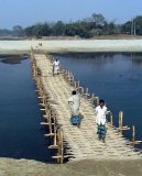
| Geography note | most of the country is situated on deltas of large rivers flowing from the Himalayas: the Ganges unites with the Jamuna (main channel of the Brahmaputra) and later joins the Meghna to eventually empty into the Bay of Bengal |
|
| People - Bangladesh: |
| Population | 150,448,339 (July 2007 est.) |
|
| Age structure | 0-14 years: 33.1% (male 25,639,640/female 24,174,937)
15-64 years: 63.4% (male 48,659,087/female 46,712,687)
65 years and over: 3.5% (male 2,818,638/female 2,443,350) (2007 est.) |
|
| Median age | total: 22.5 years
male: 22.5 years
female: 22.5 years (2007 est.) |
|
| Population growth rate | 2.056% (2007 est.) |
|
| Birth rate | 29.36 births/1,000 population (2007 est.) |
|
| Death rate | 8.13 deaths/1,000 population (2007 est.) |
|
| Net migration rate | -0.66 migrant(s)/1,000 population (2007 est.) |
|
| Sex ratio | at birth: 1.06 male(s)/female
under 15 years: 1.061 male(s)/female
15-64 years: 1.042 male(s)/female
65 years and over: 1.154 male(s)/female
total population: 1.052 male(s)/female (2007 est.) |
|
| Infant mortality rate | total: 59.12 deaths/1,000 live births
male: 60.13 deaths/1,000 live births
female: 58.05 deaths/1,000 live births (2007 est.) |
|
| Life expectancy at birth | total population: 62.84 years
male: 62.81 years
female: 62.86 years (2007 est.) |
|
| Total fertility rate | 3.09 children born/woman (2007 est.) |
|
| Hiv aids adult prevalence rate | less than 0.1% (2001 est.) |
|
| Hiv aids people living with hiv aids | 13,000 (2001 est.) |
|
| Hiv aids deaths | 650 (2001 est.) |
|
| Nationality | noun: Bangladeshi(s)
adjective: Bangladeshi |
|
| Major infectious diseases | degree of risk: high
food or waterborne diseases: bacterial diarrhea, hepatitis A and E, and typhoid fever
vectorborne diseases: dengue fever and malaria are high risks in some locations
water contact disease: leptospirosis
animal contact disease: rabies
note: highly pathogenic H5N1 avian influenza has been identified among birds in this country or surrounding region; it poses a negligible risk with extremely rare cases possible among US citizens who have close contact with birds (2007) |
|
| Ethnic groups | Bengali 98%, other 2% (includes tribal groups, non-Bengali Muslims) (1998) |
|
| Religions | Muslim 83%, Hindu 16%, other 1% (1998) |
|
| Languages | Bangla (official, also known as Bengali), English |
|
| Literacy | definition: age 15 and over can read and write
total population: 43.1%
male: 53.9%
female: 31.8% (2003 est.) |
|
| Government - Bangladesh: |
| Country name | conventional long form: Peoples Republic of Bangladesh
conventional short form: Bangladesh
local long form: Gana Prajatantri Banladesh
local short form: Banladesh
former: East Bengal, East Pakistan |
|
| Government type | parliamentary democracy |
|
| Capital | name: Dhaka
geographic coordinates: 23 43 N, 90 24 E
time difference: UTC+6 (11 hours ahead of Washington, DC during Standard Time) |
|
| Administrative divisions | 6 divisions; Barisal, Chittagong, Dhaka, Khulna, Rajshahi, Sylhet |
|
| Independence | 16 December 1971 (from West Pakistan); note - 26 March 1971 is the date of independence from West Pakistan, 16 December 1971 is known as Victory Day and commemorates the official creation of the state of Bangladesh |
|
| National holiday | Independence Day, 26 March (1971); note - 26 March 1971 is the date of independence from West Pakistan, 16 December 1971 is Victory Day and commemorates the official creation of the state of Bangladesh |
|
| Constitution | 4 November 1972, effective 16 December 1972; suspended following coup of 24 March 1982, restored 10 November 1986; amended many times |
|
| Legal system | based on English common law; has not accepted compulsory ICJ jurisdiction |
|
| Suffrage | 18 years of age; universal |
|
| Executive branch | chief of state: President Iajuddin AHMED (since 6 September 2002)
note: the country has a caretaker government until a general election is held; Iajuddin AHMED remains as President and Minister of Defense, and all other Cabinet portfolios are held by Caretaker Advisers (CAs); the Chief CA, Fakhruddin AHMED, is roughly equivalent to a prime minister
elections: president elected by National Parliament for a five-year term (eligible for a second term); election scheduled for 16 September 2002 was not held since Iajuddin AHMED was the only presidential candidate; he was sworn in on 6 September 2002 (next election NA); following legislative elections, the leader of the party that wins the most seats is usually appointed prime minister by the president
election results: Iajuddin AHMED declared president-elect by the Election Commission; he ran unopposed as president; percent of National Parliament vote - NA |
|
| Legislative branch | unicameral National Parliament or Jatiya Sangsad; 300 seats elected by popular vote from single territorial constituencies; members serve five-year terms
elections: last held 1 October 2001 (the scheduled January 2007 election has been postponed)
election results: percent of vote by party - BNP and alliance partners 41%, AL 40%, other 19%; seats by party - BNP 193, AL 58, JI 17, JP (Ershad faction) 14, IOJ 2, JP (Manzur) 4, other 12; note - the election of October 2001 brought to power a majority BNP government aligned with three other smaller parties - JI, IOJ, and Jatiya Party (Manzur) |
|
| Judicial branch | Supreme Court (the chief justices and other judges are appointed by the president) |
|
| Political parties and leaders | Awami League or AL [Sheikh HASINA]; Bangladesh Communist Party or BCP [Saifuddin Ahmed MANIK]; Bangladesh Nationalist Party or BNP [Khaleda ZIA]; Islami Oikya Jote or IOJ [Mufti Fazlul Haq AMINI]; Jamaat-e-Islami Bangladesh or JIB [Motiur Rahman NIZAMI]; Jatiya Party or JP (Ershad faction) [Hussain Mohammad ERSHAD]; Jatiya Party (Manzur faction) [Naziur Rahman MANZUR]; Liberal Democratic Party or LDP [Badrudozza CHOWDHURY and Oli AHMED] |
|
| Political pressure groups and leaders | NA |
|
| International organization participation | ARF, AsDB, BIMSTEC, C, CP, FAO, G-77, IAEA, IBRD, ICAO, ICC, ICCt (signatory), ICRM, IDA, IDB, IFAD, IFC, IFRCS, IHO, ILO, IMF, IMO, IMSO, Interpol, IOC, IOM, IPU, ISO, ITSO, ITU, ITUC, MIGA, MINURSO, MONUC, NAM, OIC, OPCW, SAARC, SACEP, UN, UNCTAD, UNESCO, UNHCR, UNIDO, UNMEE, UNMIL, UNMIS, UNOCI, UNOMIG, UNWTO, UPU, WCL, WCO, WFTU, WHO, WIPO, WMO, WTO |
|
| Diplomatic representation in the us | chief of mission: Ambassador (vacant); note - ambassador-designate M. Humayun KABIR
chancery: 3510 International Drive NW, Washington, DC 20008
telephone: [1] (202) 244-0183
FAX: [1] (202) 244-5366
consulate(s) general: Los Angeles, New York |
|
| Diplomatic representation from the us | chief of mission: Ambassador Patricia A. BUTENIS
embassy: Madani Avenue, Baridhara, Dhaka 1212
mailing address: G. P. O. Box 323, Dhaka 1000
telephone: [880] (2) 885-5500
FAX: [880] (2) 882-3744 |
|
| Flag description | green field with a large red disk shifted slightly to the hoist side of center; the red disk represents the rising sun and the sacrifice to achieve independence; the green field symbolizes the lush vegetation of Bangladesh |
|
| Economy - Bangladesh: |
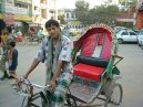
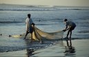
| Economy overview | Despite sustained domestic and international efforts to improve economic and demographic prospects, Bangladesh remains a poor, overpopulated, and inefficiently-governed nation. Although more than half of GDP is generated through the service sector, nearly two-thirds of Bangladeshis are employed in the agriculture sector, with rice as the single-most-important product. Major impediments to growth include frequent cyclones and floods, inefficient state-owned enterprises, inadequate port facilities, a rapidly growing labor force that cannot be absorbed by agriculture, delays in exploiting energy resources (natural gas), insufficient power supplies, and slow implementation of economic reforms. Reform is stalled in many instances by political infighting and corruption at all levels of government. Opposition from the bureaucracy, public sector unions, and other vested interest groups also have blocked progress. The BNP government, led by Prime Minister Khaleda ZIA, has the parliamentary strength to push through needed reforms, but the partys political will to do so has been lacking in key areas. On an encouraging note, growth has been a steady 5-6% for the past several years. |
|
| Gdp purchasing power parity | $336.7 billion (2006 est.) |
|
| Gdp official exchange rate | $69.34 billion (2006 est.) |
|
| Gdp real growth rate | 6.6% (2006 est.) |
|
| Gdp per capita ppp | $2,300 (2006 est.) |
|
| Gdp composition by sector | agriculture: 19.9%
industry: 20.6%
services: 59.5% (2006 est.) |
|
| Labor force | 68 million
note: extensive export of labor to Saudi Arabia, Kuwait, UAE, Oman, Qatar, and Malaysia; workers remittances estimated at $4.8 billion in 2005-06. (2006 est.) |
|
| Labor force by occupation | agriculture: 63%
industry: 11%
services: 26% (FY95/96) |
|
| Unemployment rate | 2.5% (includes underemployment) (2006 est.) |
|
| Population below poverty line | 45% (2004 est.) |
|
| Household income or consumption by percentage share | lowest 10%: 3.9%
highest 10%: 28.6% (1995-96 est.) |
|
| Distribution of family income gini index | 31.8 (2000) |
|
| Inflation rate consumer prices | 7.2% (2006 est.) |
|
| Investment gross fixed | 24.9% of GDP (2006 est.) |
|
| Budget | revenues: $6.389 billion
expenditures: $8.694 billion; including capital expenditures of $NA (2006 est.) |
|
| Public debt | 46.7% of GDP (2006 est.) |
|
| Agriculture products | rice, jute, tea, wheat, sugarcane, potatoes, tobacco, pulses, oilseeds, spices, fruit; beef, milk, poultry |
|
| Industries | cotton textiles, jute, garments, tea processing, paper newsprint, cement, chemical fertilizer, light engineering, sugar |
|
| Industrial production growth rate | 7.2% (2006 est.) |
|
| Electricity production | 18.09 billion kWh (2004) |
|
| Electricity consumption | 16.82 billion kWh (2004) |
|
| Electricity exports | 0 kWh (2004) |
|
| Electricity imports | 0 kWh (2004) |
|
| Oil production | 6,813 bbl/day (2004) |
|
| Oil consumption | 85,000 bbl/day (2004 est.) |
|
| Oil exports | NA bbl/day |
|
| Oil imports | NA bbl/day |
|
| Oil proved reserves | 56 million bbl (1 January 2005) |
|
| Natural gas production | 13.1 billion cu m (2004 est.) |
|
| Natural gas consumption | 13.1 billion cu m (2004 est.) |
|
| Natural gas exports | 0 cu m (2004 est.) |
|
| Natural gas imports | 0 cu m (2004 est.) |
|
| Natural gas proved reserves | 300.2 billion cu m (1 January 2005 est.) |
|
| Current account balance | $339 million (2006 est.) |
|
| Exports | $11.17 billion (2006 est.) |
|
| Exports commodities | garments, jute and jute goods, leather, frozen fish and seafood (2001) |
|
| Exports partners | US 25.2%, Germany 12.7%, UK 9.9%, France 5% (2006) |
|
| Imports | $13.77 billion (2006 est.) |
|
| Imports commodities | machinery and equipment, chemicals, iron and steel, textiles, foodstuffs, petroleum products, cement |
|
| Imports partners | China 18%, India 12.7%, Kuwait 8%, Singapore 5.6%, Hong Kong 4.2% (2006) |
|
| Reserves of foreign exchange and gold | $3.278 billion (2006 est.) |
|
| Debt external | $22.55 billion (2006 est.) |
|
| Economic aid recipient | $1.575 billion (2000 est.) |
|
| Currency code | taka (BDT) |
|
| Exchange rates | taka per US dollar - 69.031 (2006), 64.328 (2005), 59.513 (2004), 58.15 (2003), 57.888 (2002) |
|
| Communications - Bangladesh: |
| Fiscal year | 1 July - 30 June |
|
| Telephones main lines in use | 1.134 million (2006) |
|
| Telephones mobile cellular | 19.131 million (2006) |
|
| Telephone system | general assessment: totally inadequate for a modern country
domestic: modernizing; introducing digital systems; trunk systems include VHF and UHF microwave radio relay links, and some fiber-optic cable in cities
international: country code - 880; satellite earth stations - 6; international radiotelephone communications and landline service to neighboring countries (2005) |
|
| Radio broadcast stations | AM 15, FM 13, shortwave 2 (2006) |
|
| Television broadcast stations | 15 (1999) |
|
| Internet country code | .bd |
|
| Internet hosts | 469 (2006) |
|
| Internet users | 450,000 (2006) |
|
| Transportation - Bangladesh: |
| Airports | 16 (2006) |
|
| Airports with paved runways | total: 15
over 3,047 m: 1
2,438 to 3,047 m: 4
1,524 to 2,437 m: 4
914 to 1,523 m: 1
under 914 m: 5 (2006) |
|
| Airports with unpaved runways | total: 1
1,524 to 2,437 m: 1 (2006) |
|
| Pipelines | gas 2,604 km (2006) |
|
| Railways | total: 2,768 km
broad gauge: 946 km 1.676-m gauge
narrow gauge: 1,822 km 1.000-m gauge (2006) |
|
| Roadways | total: 239,226 km
paved: 22,726 km
unpaved: 216,500 km (2003) |
|
| Waterways | 8,370 km
note: includes up to 3,060 km main cargo routes; network reduced to 5,200 km in dry season (2006) |
|
| Merchant marine | total: 42 ships (1000 GRT or over) 341,733 GRT/485,840 DWT
by type: bulk carrier 3, cargo 29, container 6, passenger/cargo 1, petroleum tanker 3
foreign-owned: 1 (China 1)
registered in other countries: 10 (Antigua and Barbuda 4, Comoros 1, Malta 3, Saint Vincent and the Grenadines 1, Singapore 1) (2006) |
|
| Ports and terminals | Chittagong, Mongla Port |
|
| Military - Bangladesh: |
| Military branches | Bangladesh Defense Force: Bangladesh Army, Bangladesh Navy, Bangladesh Air Force (Bangladesh Biman Bahini, BAF) (2006) |
|
| Military service age and obligation | 18 years of age for voluntary military service; no conscription (2005) |
|
| Manpower available for military service | males age 18-49: 35,170,019 (2005 est.) |
|
| Manpower fit for military service | males age 18-49: 26,841,255 (2005 est.) |
|
| Refugees and internally displaced persons | refugees (country of origin): 21,053 (Burma)
IDPs: 65,000 (land conflicts, religious persecution) (2006) |
|
| Military expenditures percent of gdp | 1.5% (2006) |
|
| Disputes international | discussions with India remain stalled to delimit a small section of river boundary, exchange territory for 51 small Bangladeshi exclaves in India and 111 small Indian exclaves in Bangladesh, allocate divided villages, and stop illegal cross-border trade, migration, violence, and transit of terrorists through the porous border; Bangladesh resists Indias attempts to fence or wall off high-traffic sections of the porous boundary; a joint Bangladesh-India boundary inspection in 2005 revealed 92 pillars are missing; dispute with India over New Moore/South Talpatty/Purbasha Island in the Bay of Bengal deters maritime boundary delimitation; 21,000 Burmese Rohingya Muslim refugees reside in two camps in Bangladesh |
|
This page was last updated on 16 September, 2007